Burlingame
Setting Standards for Food-Resilient Development
Recommendation:
As cities develop, some of that development may occur in areas at risk of climate-driven flooding. To address this, we recommend that cities create overlay districts. Sea level rise and groundwater rise overlay districts map out which geographical areas will be affected by flooding under future climate conditions and apply specific development requirements or restrictions on those areas. Overlay districts can be created through a zoning code update and are a key step in ensuring that flood-resilient development conditions are implemented and enforced. OneShoreline’s Planning Policy Guidance provides template language for creating Sea Level Rise and Groundwater Rise Overlay Districts.
Example:
In 2021, Burlingame updated its zoning ordinance to include regulations for the Bayfront Commercial District, including guidelines for new development to be resilient to sea level rise. The zoning code update outlines public access, flood, and sea level rise performance guidelines for new developments. It adopts Burlingame’s Map of Future Conditions, including a Sea Level Rise Overlay District, which is based on the Our Coast Our Future hazard map.
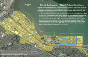
Burlingame Map of Future Conditions, City of Burlingame