Save The Bay
Skip to content
  • Who We Are
    • About Us
    • Our Impact
    • Meet Our Team
    • Work With Us
  • What We Do
    • Advocate
    • Restore
    • Connect
  • Get Involved
    • Volunteer
    • Take Action
    • Student Programs
    • Fellowship Program
    • Calendar
  • Ways To Give
    • Bay Sustainer
    • Legacy Giving
    • Corporate Partnerships
    • Stock, DAF & IRA Gifts
    • Matching & Workplace Giving
    • Vehicle Donations
  • Bay Stories
    • DONATE
    • Subscribe
    0 events found.

    Events for March 13, 2026

    Notice
    No events scheduled for March 13, 2026. Jump to the next upcoming events.
    Notice
    No events scheduled for March 13, 2026. Jump to the next upcoming events.

    Events Search and Views Navigation

    Event Views Navigation

    • List
    • Month
    • Day
    Today
    • Previous Day
    • Next Day
    • Google Calendar
    • iCalendar
    • Outlook 365
    • Outlook Live
    • Export .ics file
    • Export Outlook .ics file

    610 16th Street, Suite 520
    Oakland, CA 94612

    Save The Bay is a 501(c)(3) nonprofit organization. Gifts are tax deductible to the fullest extent of the law. Our tax identification number is 94-6078420.

    By contributing information about our mission, staff and leadership, programs, goals, and more – Save The Bay has earned a Candid Platinum Seal of Transparency on GuideStar.

    CONTACT US

    WORK WITH US

    GIFT POLICIES

    FINANCIALS

    PRIVACY POLICY

    DONATE TO SAVE THE BAY

    2025-2030 STRATEGIC PLAN

    SAVE THE BAY ACTION FUND

    • Instagram
    • LinkedIn
    • Facebook
    • YouTube
    Indigo Theme by Artisan Themes

      Storm Drain Master Plan

      Cities should create storm drain master plans that identify areas at risk of flooding due to current and future storms and identify projects to ensure the storm drain system has the capacity to function under future conditions. Identified projects should be prioritized based on future flood risk, water quality, and benefits to disadvantaged communities. As much as possible, the city should identify green stormwater infrastructure solutions to drainage issues; this could take the form of a green streets master plan.

      Examples

      Pacifica

      Pacifica’s Storm Drain Master Plan identifies capacity deficiencies in the storm drainage system, develops feasible alternatives to correct these deficiencies, and plans the infrastructure that will serve future development. It includes an analysis of future precipitation impacts on the storm drain system.

      San Mateo County

      The San Mateo Countywide Green Streets Master Plan identifies “how and where to build sustainable streets in San Mateo County that integrate stormwater management with local priorities, like bike and pedestrian mobility, transit improvements, climate change adaptation, and more.” It includes an analysis of stormwater runoff under future climate scenarios, which determined that the planned green street projects could offset the projected roadway runoff due to climate change for a 2-year storm. Additionally, the green streets projects were prioritized based on water quality, flood risk, water supply, climate change impacts, groundwater constraints, utility constraints, vulnerable community indicators, vehicle ownership statistics, urban canopy, and urban heat island effect.

      Integrating Flood Resilience Into Capital Improvement Planning

      Local jurisdictions must ensure that public infrastructure (such as parks, streets, sewers, stormwater infrastructure, and shoreline infrastructure) are designed for flood resilience and incorporate nature-based solutions wherever possible. They can do this by creating capital improvement planning processes to ensure all proposed projects are evaluated for flood resilience and green infrastructure potential.

      Examples

      Burlingame

      Burlingame has a green infrastructure checklist used to evaluate opportunities to include green stormwater infrastructure (GSI) features in capital projects. This approach ensures that no opportunities for GSI are missed. It can be found in Appendix B of the city’s Green Infrastructure Plan.

      San Francisco

      San Francisco has a “Guidance for Incorporating Sea Level Rise into Capital Planning in San Francisco Sea Level Rise Checklist”. Using this checklist ensures that all capital projects planned in the sea level rise vulnerability zone are resilient to sea level rise.

      Shoreline Resilience Plan 

      With the passage of SB 272 (Laird, 2014), Bay Area cities are required to create Shoreline Resilience Adaptation Plans (RSAPs) and have those plans approved by the Bay Conservation and Development Commission (BCDC) by 2034. BCDC has released draft RSAP guidelines which cities must follow when creating their shoreline plans. The guidelines will be finalized at the end of 2024. We hope to see the final guidelines reinforce an emphasis on nature-based solutions, public access, and community engagement. 

      Examples

      Hayward

      The Hayward Regional Shoreline Adaptation Master Plan (HRSAP) was created in 2021 to establish a vision and adaptation strategies for protecting natural and built shoreline assets from sea level rise. It recommends shoreline resilience projects such as horizontal levees, gently sloping vegetated buffers that provide sea level rise protection and water quality benefits. The HRSAP was created by a joint powers authority consisting of the City, the Hayward Area Park and Recreation District (HARD), and the East Bay Regional Park District.

      Sea Level Rise and Groundwater Rise Overlay Districts 

      Sea level rise and groundwater rise overlay districts map out which geographical areas will be affected by flooding under future climate conditions and apply specific development requirements or restrictions on those areas. Overlay districts can be created through a zoning code update and are a key step in ensuring that flood-resilient development conditions are implemented and enforced. OneShoreline’s Planning Policy Guidance provides template language for creating Sea Level Rise and Groundwater Rise Overlay Districts.

      Examples

      Burlingame

      In 2021, Burlingame updated its zoning ordinance to include regulations for the Bayfront Commercial District, including guidelines for new development to be resilient to sea level rise. Section 25.12.050 outlines public access, flood, and sea level rise performance guidelines for new developments. It adopts Burlingame’s Map of Future Conditions, including a Sea Level Rise Overlay District, which is based on the Our Coast Our Future hazard map.

      South San Francisco

      In 2022, South San Francisco (SSF) updated its zoning code to include a Flood Plain/Sea Level Rise overlay district. The overlay district includes areas that will flood under a 36-inch sea level rise scenario and a 100-year storm. It imposes new construction requirements including base flood elevations sufficient to protect against the FEMA 100-year event with 3 feet of sea level rise, nature-based stormwater infrastructure designed to function under future conditions, and a bay access buffer within 100 ft from the shoreline.

      Highway 37

      Highway 37 will soon be underwater. The highway’s redesign, if done correctly, offers an opportunity to build climate-resilient infrastructure and restore 20,000 acres of wetlands.

      Aerial of a 3 lane highway with marsh on the left side and water on the right
      Highway 37 on a dry day, Karl Nielsen

      The Issue

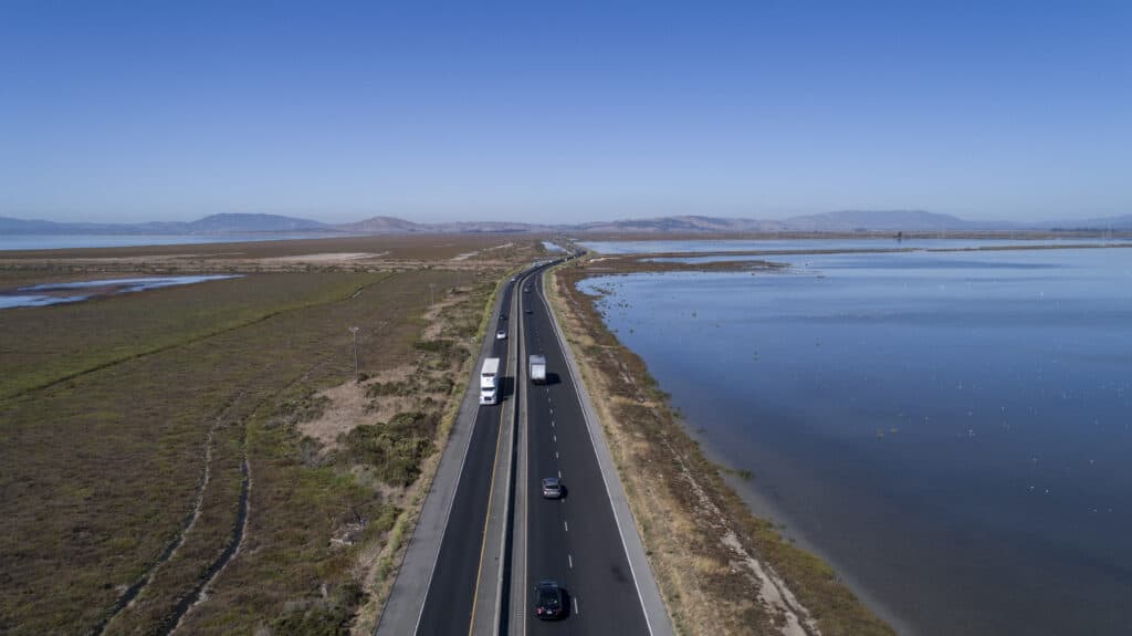
      Highway 37 sits on a levee in San Pablo Bay in the north Bay Area.  In 2017, the highway was shut down for a month due to flooding caused by a combination of King Tides and winter storms. During the atmospheric rivers in January 2023, the highway was again closed for a weekend when it flooded due to Novato Creek overflowing. These closures will likely happen again and again as sea levels rise if no action is taken. This would disrupt 40,000 daily car trips which people depend on to get them to jobs in Marin, Sonoma, Napa and Solano Counties. Additionally, the levee that the highway sits on currently blocks natural tide flow from San Pablo Bay to wetlands on the north side of the highway.  


      The Solution

      The redesign of Highway 37 is currently in the early planning stages. One of the proposed designs is to build the highway on an elevated causeway. This would put the highway above the reach of rising sea levels while also letting water ebb and flow with natural tidal action between San Pablo Bay and the wetlands beyond the highway. Once these 20,000 acres of wetlands are reconnected with the natural flow of tides, they can be restored to their full function, providing habitat, carbon sequestration, and flood resilience benefits.  

      Highway 37 and Bay Area Conservation Initiatives.

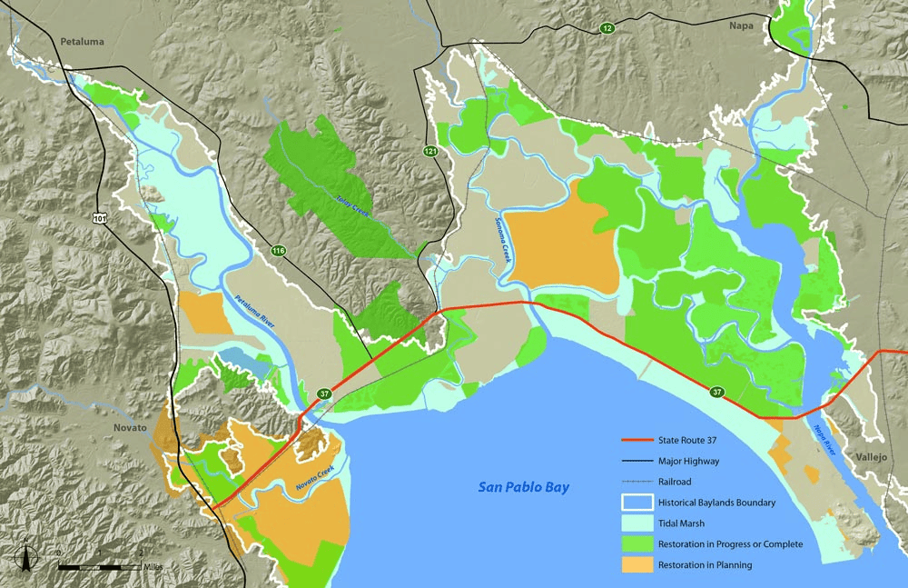
      Photo: Sonoma Land Trust 


      The Partners

      SR 37 Baylands Group (Audubon California, California Department of Fish and Wildlife, Ducks Unlimited Inc., Marin Audubon, Marin Conservation League, Point Blue Conservation Science, San Francisco Bay Joint Venture, San Francisco Bay Regional Water Quality Control Board,. San Francisco Estuary Institute,. San Pablo Bay National Wildlife Refuge, U.S. Fish and Wildlife Service, Save The Bay, Sonoma Land Trust,. State Coastal Conservancy) 

      AstraZeneca Toxic Site

      Groundwater and sea level rise threaten vulnerable communities by displacing toxic contamination.

      Aerial video of plot of land on the shoreline
      Richmond, CA, San Francisco Business Times

      The Issue

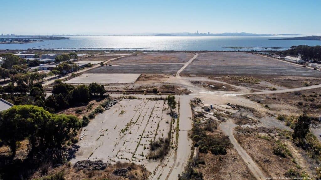
      The AstraZeneca site on the Richmond shoreline was once the site of sulfuric acid, pesticide, and fertilizer manufacturing. Because of this industrial pollution, it is now contaminated with high levels of toxins such as benzene, lead, arsenic, uranium, and pesticides like DDT. So far, cleanup efforts have included leaving contaminated soil on site and “capping” it by placing concrete on top. The City of Richmond has plans to build up to 4,000 housing units on top of this contaminated land. However, as sea levels rise, groundwater will also be pushed up to the surface, potentially pushing the toxins into pipes and through cracked concrete, putting the health of residents and surrounding communities at risk.   


      The Solution

      For decades, frontline community members in Richmond have been raising awareness about the health and environmental threats posed by groundwater and sea level rise displacing toxic contaminants on industrial sites. Because of a long history of racist policies, the communities surrounding these sites are largely low-income communities of color. They are advocating for full cleanup of the AstraZeneca site before any housing is built on it, rather than simply capping contamination in place. This would involve removing all contamination from the site and taking it to a safer storage or treatment site. The Department of Toxic Substances Control (DTSC), which oversees cleanup of the site, should require AstraZeneca to conduct a full cleanup. Additionally, groundwater and sea level rise should be considered in all toxic site cleanup efforts.


      Community Advocates

      Richmond Shoreline Alliance (Sunflower Alliance, Greenaction, Sierra Club, CESP, Point Molate Alliance, Richmond Progressive Alliance)

      San Mateo County

      Of all the counties in California, San Mateo County is the most vulnerable to sea level rise. 

      Road closed and car trapped in flooded street under highway underpass
      San Mateo, January 2, 2023, Bruce Washburn

      The Issues

      Sea Level Rise 

      Sea levels could rise by up to 3.3 feet in San Mateo County by 2070 and 6 feet by 2100 according to the county’s Sea Level Rise Vulnerability Assessment. While the whole Bay Area will experience rising seas, San Mateo County is particularly vulnerable, with over 30,000 homes, dozens of schools and hospitals, and over 7,000 acres of wetlands at risk of flooding by 2070. Historically underinvested communities will be the most at risk when flooding occurs because historic inequities placed affordable housing in higher flood risk areas and because they are more vulnerable to economic damages incurred.  
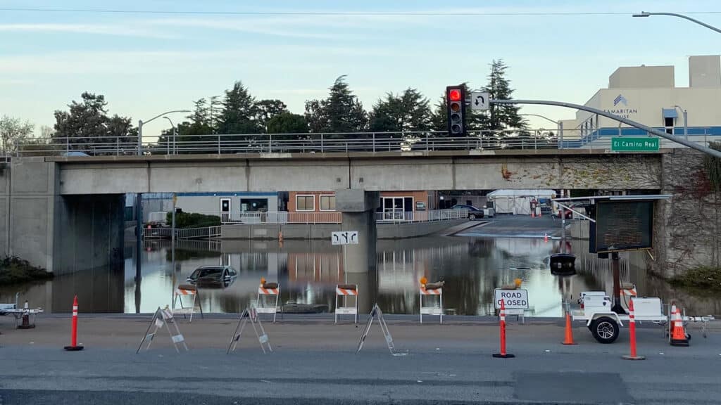
      Inland Flooding 

      Not all flooding happens at the coast. As storms and groundwater rise become more extreme, Bay Area communities will continue to be impacted by flooded streets and homes due to outdated stormwater infrastructure. Additionally, urban areas are primarily covered in concrete, asphalt, and other surfaces that don’t allow water to seep through. This means that during storms, rainwater runs off these surfaces picking up pollutants (like motor oil, chemicals, and trash) on its way to creeks and the Bay. 


      The Solutions

      Sea Level Rise 

      Preparing the county for sea level rise will require a coordinated effort among cities to plan and implement solutions such as wetland restoration, horizontal levees, and sea walls. San Mateo County has taken steps in this direction with the creation of OneShoreline, a government agency that works across jurisdictional boundaries to plan and implement sea level rise resilience measures in the county. The County also conducted a countywide Sea Level Rise Vulnerability Assessment to identify areas that will be impacted by flooding and erosion and provide solutions. 

      This coordinated effort should be replicated across the Bay Area. Cooperation between cities and counties throughout the Bay Area is necessary to ensure that shoreline protection in one area doesn’t result in greater flooding in others. This could happen, for example, when a sea wall in one city deflects storm surges towards an adjacent city without flood protections. There should also be coordination at the state and federal level to provide funding to low-income cities that may not otherwise have resources for sea level rise planning. The San Francisco Bay Conservation and Development Commission (BCDC) is currently creating guidelines to shape local sea level rise plans.   

      Inland Flooding 

      Cities must invest in updated stormwater infrastructure to reduce flooding and capture and clean stormwater before it reaches our waterways. In particular, green stormwater infrastructure (GSI) uses natural systems like vegetation, soil, and permeable surfaces to capture stormwater and filter out pollutants. Examples include rain gardens, bioswales, and tree wells. When cities upgrade streets, parks, and other infrastructure, they could be incorporating GSI at the same time, making these new investments more flood resilient.  San Mateo County is supporting this kind of integrated planning with their Sustainable Streets Master Plan. 


      The Partners

      OneShoreline, County of San Mateo 

      Favorite native plant or animal: Burrowing Owl

      Favorite thing to do in the Bay Area: Riding my bike, birding and taking photos

      Superpower: Converting micro plastics into sustainable transportation

      Steve Dakin

      Adobe


      Steve is a Bay Area native whose love of hiking and cycling has deepened his appreciation for the region’s natural beauty.

      As a Director of Engineering at Adobe, he focuses on building solutions that benefit everyone. He joined Save The Bay’s Board of Directors to combine his passion for the environment and the Bay Area with his technical expertise, to help preserve the beauty of the San Francisco Bay for all to enjoy.