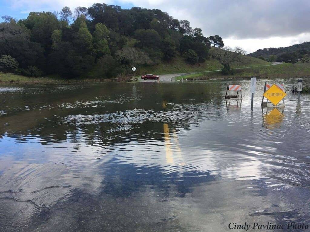
King Tides dramatically arrived in early December causing widespread flooding across the Bay Area region.1 These exceptionally high tides provide us with an important glimpse into our future. You may have encountered flooded sidewalks as you walked along the Embarcadero in San Francisco, or had to drive through an inundated North San Pedro Road in China Camp State Park, or even seen water rising up to seating areas along Jack London Square in Oakland. All of this flooding was caused by King Tides, which occur twice each year when the moon, sun, and Earth align to create the strongest gravitational force on our oceans.2 King Tides are much more than just receding flood events. They actually provide insight as to what the daily high tide will look like in the coming years with permanent sea level rise, and thus how we need to prepare now to meet this challenge.
Addressing the Threat of Sea Level Rise
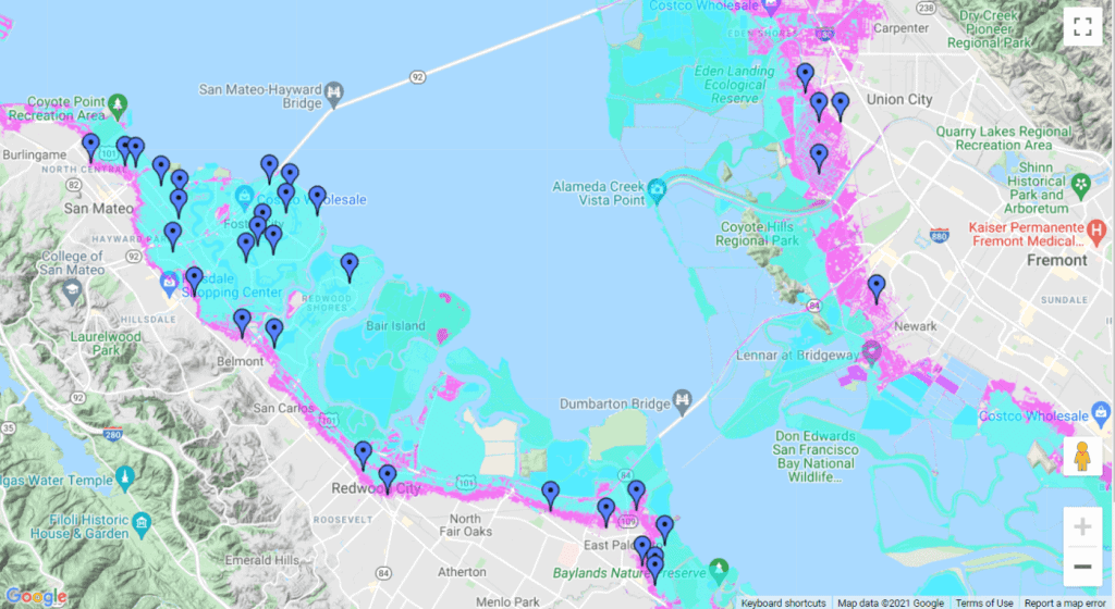
Permanent sea level rise will happen in the Bay Area, with estimates ranging between 1.9 and 3.5 feet by as early as 2050, and up to seven feet by 2100. By the end of this century, the Pacific Institute’s Sea Level Rise mapping tool has estimated that 70 local schools will be in a flood risk area [see Figure 1]. Even under a conservative assumption of two feet of sea level rise, 13 miles of highway would flood (portions of Route 37, 101, and 580 among others), according to the Adapting to Rising Tides Flood Explorer [see Figure 2].3 This may not seem like much at first glance, but that flooding would impact 1,491,600 vehicle trips every day. This problem becomes even more concerning when sea level rise combines with storm surges and rising groundwater tables, which can cause pockets of flooding further inland in areas we might not expect.4 Homes, businesses, critical public infrastructure, and even public health will be compromised if we do not take collective action soon, and our most vulnerable shoreline communities will continue to bear the brunt of the impacts.
Rehabilitation of the Bay’s historic tidal marshes is a critical nature-based strategy that can help the Bay Area adapt to rising sea levels. 90 percent of the Bay Area’s wetlands from 200 years ago have been destroyed, which has exposed shoreline communities to sea level rise and storm surges. This is why Save the Bay, along with our partners, campaigned for the successful passage of Measure AA in 2016. This parcel tax, which supplies funding over the next 15 years for wetland restoration efforts across the Bay Area, has supported dozens of projects that provide benefits for community and habitat protection. As seas rise, these rebuilt wetlands will be able to soak up large quantities of water, providing a natural buffer for shoreline infrastructure and an area for native wetland species to migrate upland.5 One project that Save The Bay’s Habitat Restoration Team is directly involved with at Ravenswood, which is part of the South Bay Salt Ponds Project, is a 9.6 acre natural levee that will eventually be populated by native grasses and plants, providing a natural shoreline protection system for the low-lying community of East Palo Alto.6
Laying the Groundwork in Cities and the Shoreline
Nature-based strategies, however, must work in tandem with forward-thinking policy measures to determine where and how we grow as a region. Burlingame is taking the first step toward ensuring that new development will be more resilient to flood risk through requiring setbacks from creeks and the shoreline while also implementing elevation standards to build development above the projected base flood elevation level. This is the first example in the Bay Area of a city proactively amending its zoning code to account for sea level rise and likely will not be the last. Other San Mateo County cities understand the importance of this strategy, and are in the process of taking similar steps to protect infrastructure from rising sea levels.
Although the Bay Area has made significant investments in shoreline projects and is starting to develop policies to reduce future flood risk, seas are rising faster than our current adaptation efforts. This is why Save the Bay assisted with the recent release of the Resilience Playbook, which offers a roadmap to equitable land use policies to guide sea level rise (and other climate adaptation efforts) planning around the Bay Area. A piecemeal city by city approach will not suffice and ultimately, it will leave less-resourced cities behind and likely increase the overall risk in vulnerable areas. Marin City, the Bayview in San Francisco, and the city of Richmond have seen consistent flooding for decades, and when flooding is coupled with the presence of toxic waste sites, it causes widespread public health issues. A coordinated, regional strategy is the best way to ensure that all cities, especially those who have suffered from historic environmental injustice, are prepared for this looming risk.
Tackling sea level rise is even more difficult when shoreline jurisdictions aren’t working collaboratively. 78 percent of Bay Area cities who participated in a recent sea level rise adaptation progress survey stated that they wanted better relationships with their neighboring towns and cities,7 clearly articulating the need for a regional approach. Save the Bay supports a regional strategy that includes substantial guidelines for new and existing development, coordinated roles for local, state, and federal agencies, community engagement to reduce local flood risk, and streamlined funding sources to assist local governments with planning and implementation efforts. It is evident that cities already recognize that they need this type of coordinated effort, but it will likely require strong leadership at the state level to adapt effectively.
The flood risk that communities will face in the coming years mirrors what King Tides show us today. Infrastructure along the shoreline will be severely threatened, and entire communities eventually may be forced to vacate the area unless we plan for the future. How we plan for that future needs to start now, and Save the Bay will continue to support regional efforts to create a flood resilient Bay Area in a future of rising tides.
[1] Charnock, Matt. “Photos: King Tides Offer Window into a Bay Area Marked by the Climate Crisis.” SFist, SFist – San Francisco News, Restaurants, Events, & Sports, 6 Dec. 2021, https://sfist.com/2021/12/05/photos-king-tides-offer-window-into-a-bay-area-marked-by-the-climate-crisis/.
[2] Quigley, Josh. “Return of the King.” Save The Bay, Save The Bay, 17 Nov. 2020, https://savesfbay.org/return-of-the-king-tides.
[3] “Adapting to Rising Tides Flood Explorer.” Art Bay Shoreline Flood Explorer, San Francisco Bay Conservation and Development Commission Adapting to Rising Tides Program and San Francisco Estuary Institute, 2019, https://explorer.adaptingtorisingtides.org/explorer.
[4] Befus, Kevin, et al. “Bay Area Groundwater and Sea Level Rise Workshop Summary November 2019.” San Francisco Bay Conservation and Development Commission Adapting to Rising Tides Project, 13 Nov. 2019.
[5] “Restoring Our Wetlands.” Save The Bay, Save The Bay, https://savesfbay.org/what-we-do/restoring-our-wetlands.
[6] Onorati, Charlie. “Ravenswood Horizontal Levee Project.” Save The Bay, Save The Bay, 5 Nov. 2021, https://savesfbay.org/ravenswood-horizontal-levee-project.
[7] BCDC, et al. “2021 Sea Level Rise Adaptation Progress, Gaps & Needs Survey Report: 2021 Survey of Sea Level Rise Adaptation in the Bay Area.” 2021 Sea Level Rise Adaptation Progress, Gaps & Needs Survey Report, 2021, http://www.adaptingtorisingtides.org/wp-content/uploads/2021/11/2021-Progress-Gaps-Needs-Survey-Report_final_ADA.pdf.
[8] Pavlinac, Cindy. “North San Pedro Road, China Camp State Park.” California King Tides Project, 2021, https://www.coastal.ca.gov/kingtides/gallery.html.
[9] “Schools at Risk of 100 Year Flood Event in the South Bay.” Pacific Institute, 2021, https://pacinst.org/reports/sea_level_rise/.
[10] “Map of Highways Impacted by 24 Inches of SLR in the North Bay.” Adapting to Rising Tides Project Flood Explorer, BCDC, https://explorer.adaptingtorisingtides.org/explorer.